537 km
We used the free Avenza topographic maps to have a closer
look at what was around 20 years ago and identified a few areas of
interest. Having left Jan and Ross way
behind , we deviated in to Coragina Rock and the dry waterhole next to it.
Another of the bare granite rocks that abound in the area.
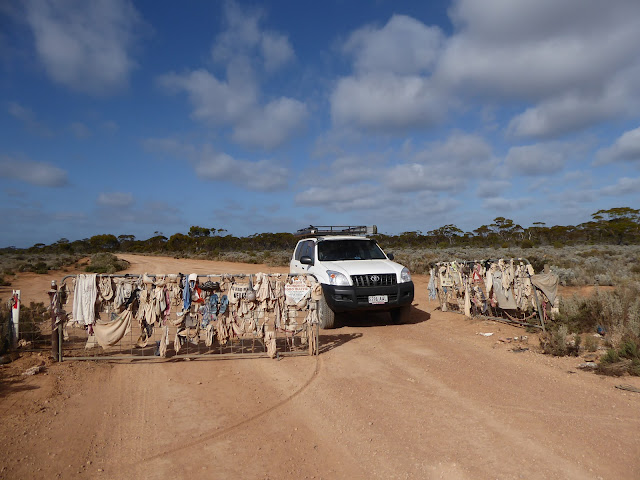
We passed the undies and bottle gate and took another photo
of the naked man trophy. Maybe he could
adopt the bonds jocks on offer on the gate for covering? – I left my one blue
thong (the partner of which is along the 4WD track somewhere).
A while up the truck we passed the next undies gate.
A while up the truck we passed the next undies gate.
Trev spotted an old car through the trees and we pulled over
to investigate – a blue Ford Explorer has been driven to here (with mattress in
the back) and then trashed – how on earth did the driver get out to
civilization again?? – we wondered how they even got the car in to the bush
where they had . Smashed windows all around. Trashed completely. At least there were no bodies in it.
We had no contact with Ross and Jan once they were out of
UHF radio range, so no idea at all of how far away behind us they were. We decided to deviate into the water reserve
shown on the topo map. We finally found
Yadadiinia Rockhole in thoroughly burnt out country after following a very vague
track , and skirting around the many trees which had burnt and eventually
toppled from the base of their trunks.
As we exited the park again and headed back to our “road”
via the old telegraph track we managed to raise Ross and Jan on the radio again
– they were just passing the intersection. !!.
We had a quick stop at Balladonia for icecream treats among
the many caravans and backpackers before heading onwards towards the isolation
of the road and home.
A lunch stop 40km west of Caiguna by the big tank gave the
chance to lots of flies to hop into the car, but also a welcome brief break
from driving. We saw the fellow come and
empty some of the roadside bins (we wondered why he left others ).You can drive
further back off of the road here to camp but there are usually a lot of vans
in the later afternoon, so it would not be an ideal stop for us overnight at
any time.
Near Caiguna the first time change occurs – so we put our
clocks forward ¾ hour. The next ¾ will be tomorrow morning.
This time zone is for the unofficial hybrid time zone called Australian Central Western Standard Time which is not official, but is so accepted in the area that there are road sings to remind people of it. It is half way between the official Western and Central times (3/4 hour difference) . Apparently this quarter hour use is quite rare and found nowhere else but in Nepal and a few other small isolated areas.
ACWST is observed only in a tiny sliver in the far southeastern corner of Western Australia along the Eyre Highway, extending from just outside of Caiguna to about 50 metres across the South Australia state line to encompass Border Village, for a total length of about 340 kilometres.
We finally stopped for the night between Madura and
Mudrabilla down a track to the south alongside the rabbit proof fence among
some trees.
We had a small cooking fire (lots of dryish wood around) and one of our latest nights yet.
We had a small cooking fire (lots of dryish wood around) and one of our latest nights yet.


No comments:
Post a Comment