Showing posts with label world heritage. Show all posts

Friday, 31 May 2019

May 29th - Walking in Bath and Roman Baths


Although we had done our own walking tour of Bath the previous day, the ones with the Mayors Honorary Guides get almost all 5 start recommendations on Trip Advisor and are also completely free. What’s not to like about that??

There had also been some complaints about the reliability of the information from the previous day’s guide (me) who had made up lots of useless junk info in an attempt to entertain the walking guests, but not reliably portrayed the true Bath.

So we hot-footed it down to Bath again, just in time to catch on to the free walking tour at 1030am just outside the Roman bath.  This is super easy to find, because the Roman Bath is on the same square as the Abbey – a very tall and recognisable landmark.   

There were about 80 people standing around waiting for the tour to start in the drizzle. The crowd was split into four groups and we were allocated to John. He was quite funny (in a dry English way) and quite knowledgeable and it was well and truly worth making the effort. We revisited some of the previous day's places, but in a very different way. We learnt lots. We mostly walked in drizzle and stood in shelter to listen. 


Bath is a world heritage city (one of only two in the world - the other is Venice) 

The entrance to one of the Baths in the city - Kings and Queens Baths

the Cross Bath (you can book this for a private bath as a group)

The hot bath.  Actually they all come at 46 degrees C.  (this means that the water is emerging from just over 2 miles below the ground) 

at the side of the Cross Bath.  

The new updated city Bath.  You can swim up there.  You can also pay to have various therapies and treatments on the levels below. This new Bath complex (with filtered water so that people don't get meningitis and die) cost the city 40 million pounds and took about 6 years longer than it was supposed to.

John pointed out the differences between the three sides of The Circus. - the one on the Northern side is styled like a palace. (with a fancy bit in the centre) 

I'm really enjoying the little plants growing out of walls. 
 The Three master's levels of the  houses on The Circus each have a slightly different style on their columns
Top storey - fancy tricky stuff

Middle storey with scroll bits

Lower storey with pretty carvings and otherwise very plain.

This is a different view of the Pulteney bridge so that you can see past both the back and front of the shops on the bridge. (just behind where the car is turning the corner)  
Many people cooperated with the government and donated their lamp holders to the war effort (iron was scarce).  Sadly the streets were less light then and the metal was dumped in the Irish sea unused at the end of the war.!  Just a few remain to be admired, and you can easily imagine a light like this over every path lighting the street so people could walk home safely. 


We finished the tour back by the Abbey - where John explained that the builder of the Abbey (Bishop Oliver King) wanted his name to be remembered - even by those who didn't read, so he arranged for this stone carving to be on each corner of the Abbey - the Bishops mitre, over an Olive Tree and then the Crown!!


We were so exhausted by the information overload and the chilling cold that we sought shelter in the covered guild crafts arcade, ignoring the crafts, but seeking warm tea and curry for lunch. 
Once rejuvenated by the food and drink we decided to pay our money and see the Roman Baths (despite the high price).  

They have really put together an excellent exhibition explaining the area, how it was used and showing what has been uncovered.  We walked on the stones by the baths just as the Romans would have done!! (but didn't bathe in the water here as it is a public health risk).  If you want to bathe you go to the new pools and pay your money there. 

I hadn't realised that this was a place of worship as well as recreation and social interaction for the Romans.  I also hadn't realised what a social thing it was for the Victorians. It seems that coming to Bath for three months of vacation, leaving the kids at home with Nanny, bringing your servants with you and "taking the waters" regularly was a thing. 


A number of statues of Romans overlook the main pool.

The main pool viewed from the Terrace. It gets drained every now and then and looks clear and attractive for a while, then gets green with algae again. 


We were provided with an audio tour - dial up the number you see before you on a sign and listen to the information.  Bill
Bryson has done some commentary and you can dial up his work if you want to hear his take on some of the items  

stone carvings found and "jigsawed"  together by the archaeologists to give an idea of what they would have shown originally. Highlighted with a light display.

When not lit with the special lights.  We have seen this Celtic face over a number of doors as we make our way around Bath. 

These are metal curses - you write your curse on there, fold the metal and throw it into the pool so that the goddess can read it and act on it. 

the petty reasons for curses that have been found.. 

the sacred pool

Water flowing through the Bath area (underground) 

a pensive moment...

cute family shot.


...and one of the photographer on the opposite side of the pool


On our way home we walked past these unusual plants in the florist shop .  Apparently the Nertera or Coral Bead Plant is a ground cover which needs to stay at a temperature of 13 to 18 degrees C to stay healthy.  This is probably why we have not noticed it in SA.


The map shop also had a map over 300 years old of the Oxford area which Thom pondered over for a while through the window.  They were asking £1150 for it.


The day was completed by delicious pizza and a good SA wine. 

Sunday, 1 July 2018

Mungo National Park June 28th

This was our last available day in Mildura, so we made the most of it by leaving town!!

It had not rained for over a day, so we decided to chance the roads to Mungo National Park.
It takes a bit to get there - you are on bitumen as you cross the river and head out the Silver City Highway, then turn off on Arumpo road, but this doesn't last too long and the last 80km or so is on dirt road of varying conditions.  This road gets closed in wet weather due to the danger of driving on it and also the risk to the road surface itself.


How to head towards Mungo National Park from Mildura
The location of Mungo National Park
Mungo was privately owned as a station by Albert and Venda Barnes, who allowed visiting geologists and archeologists to come and started initial tourism early on (come and see the "Walls of China"), before selling it after the discovery of Mungo woman and Mungo Man. It then became a Park and ultimately the Willandra Lakes Region (which includes 17 lakes) was listed as a world heritage area.


The artist Russell Drysdale painted the famous "Walls of China" painting in 1945 which is still in the NSW Art Gallery
 It was a sheep station and much grazing damage has been done over the years - making the sandhill areas in particular subject to erosion as the plants were grazed and the soil exposed.
Zanci Station was next door (owned by the Vigars) and now also part of the park, along with some other neighbouring stations.

The impressive old shearing shed (made of the native pine)  remains and has been somewhat restored, along with underground tanks and ruins around the place. There were 18 stands in the shearing shed at one time.


Lake Mungo is one of the lakes in the Willandra Lakes region but has been dry for many thousands of years.(around 20,000). It was home to the native people when it had water and is still considered home by three different groups who share management input.

As  Sediments from up to 100,000 years ago were eroded by the wind the land gave up its secrets to the scientists in the 1970s and Mungo Lady (in her 20s when she died) was found to have been burnt after death (thought to be the earliest cremation) while Mungo Man (in his 50s) was painted with Ochre (also a burial rite it is thought) prior to burial. Both skeletons have been dated around 42000 years ago.  This dates humans exhibiting social rites so long ago that it is highly significant.

There is a loop drive that you can take (70km)
Loop drive shown in orange


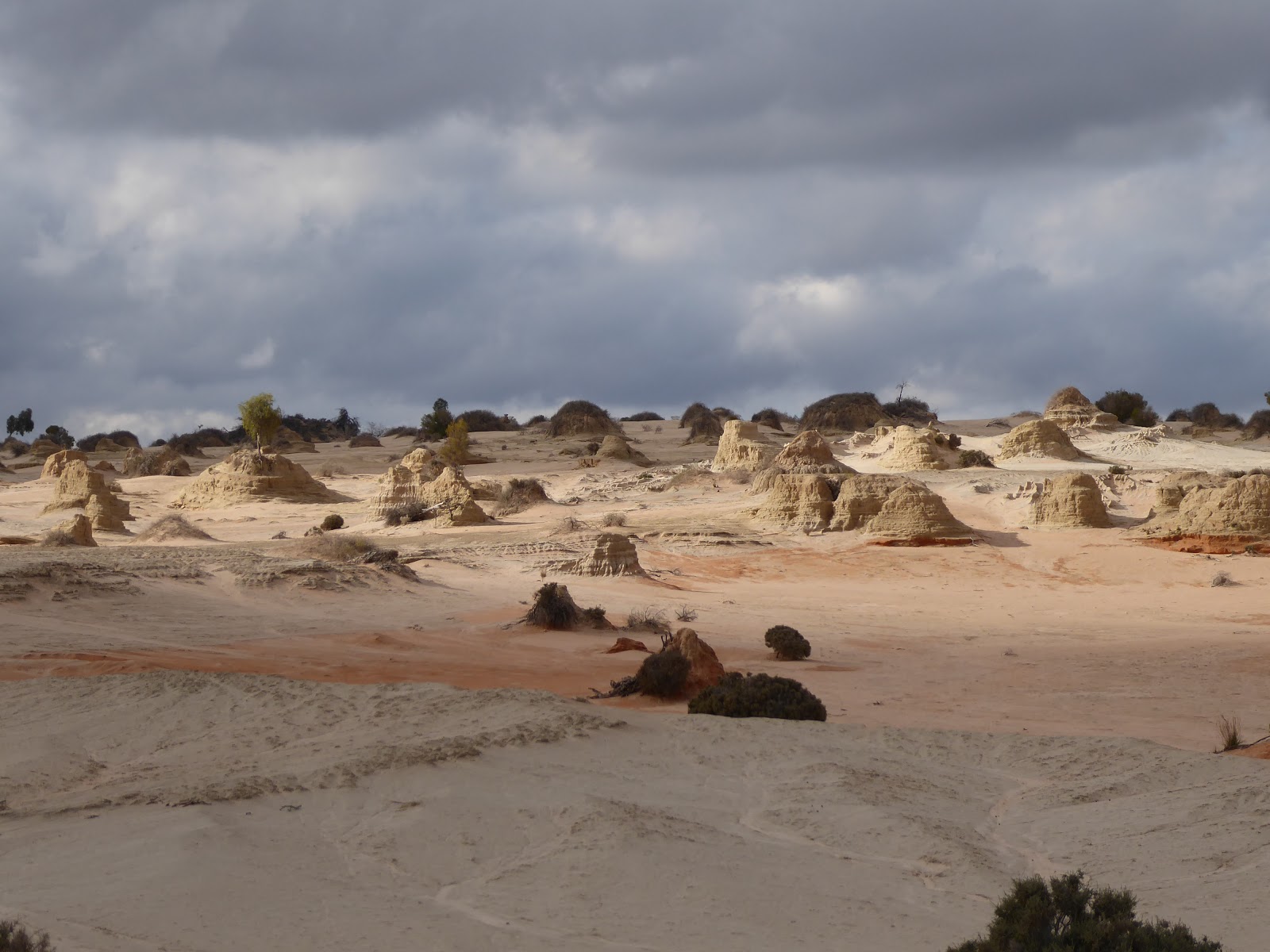
 and there are now boardwalks to walk on to see the Walls of China (hills with eroded mounds) at the Walls Lookout. The Walls of China are basically an area on the moon-shaped (Lunette) eastern side of the lake 38km long where the sand was blown to , and then eroded into strange mounds.  You can see the varying colours from the various times of deposition.


The red colour comes from 100,00- 120,000 years ago, the grey is from 50,000 to 25,000 years ago and the paler brown is from 25,000 to 15,000 years ago.  

Further along the drive you come to another boardwalk (At Red Top Lookout) where you can get up close to the erosion and see how it looks.


The formations really are quite extraordinary!! You do get a feeling that history has happened here.

Further along the drive we stopped at Rosewood Rest (among a stand of Rosewood trees on a red sand hill) to have a very late lunch


 The Mallee Stop, a little further on, gave us the opportunity to learn a bit about telling the difference between species of Mallee, and educated us on the lichen on the ground, and porcupine grass (spinifex) which is currently in flower on the 500m walk and through this area of the park. 
mallee

This particular mallee has bright orange/ red buds - very noticeable right at the moment. 
We came past the ruins of the old shepherd's hut (originally dragged here on a sled from the main station) - now just a pile of wood and metal among rabbit warrens  and wandering emus on the exposed plains. 


and later arrived at a dam (Round Tank) where a goat trap used to be set up and used.  The remnants of the goat trap remain and were interesting. The ramp (below) was for the feral goats to go up.  They would then jump over the end to get to the water (dry dam at the moment) .  The fence was high enough to keep them by the dam until they were rounded up into the yards and up the ramp (second photo below) to be taken away for culling, and thus removed from the park.  The whole thing is currently in disrepair, with a higher fence further out around the dam.


Further around the loop we came to the old Zanci Station homestead site - still with old chimney, underground covered tank and old dugout where the owners used to take refuge when it was really hot.
 Zanci station was annexed into the Park in 1984. You can still see the old border fence as you cross it. 


The old underground dugout. Refuge from searing heat. 

A final view over the dry lake as we left the park gave us the opportunity to take in the enormity of this amazing scene.


On our rather rushed trip back to Mildura we were treated to a great sunset over the vast Aussie plains.