Saturday 21 July 2018

BRAG - Bandicoot Action Recovery Group - Thursday 12th July 2018


We attended the first action of the BRAG at Deep Creek with Kate, who was staying from ACT.

I had seen the Ad on Facebook and we were interested.


We learned a bit about bandicoots and their habitat from Alisa and then went our in two groups (we were with Luke) to set up two cameras to monitor for bandicoots. 
It is a fairly complicated process, so it was good to have a group to learn in. 

This initial project is aimed at helping the Department for Environment & Water's Fire Management team to improve their understanding of the distribution of the Southern Brown Bandicoot in parks where prescribed burns are planned and reduce the threat that bushfires present to them. 

Improving knowledge about where bandicoots occur helps ensure that only small proportions of bandicoot habitat are burnt at any one time. It can also be used to help understand the habitat requirements of bandicoots and how quickly this habitat responds to fire.

 The Fire Ecology team and the Region’s Threatened Fauna Ecologist have undertaken some monitoring in the Adelaide Hills to answer these questions but more survey work is needed to ensure they are managing bandicoot habitat the best way that they can.

Luke was very complimentary about the work of our orienteering friend Dr Steve Cooper with bandicoots. 
Beautiful Deep Creek forest walk

Here we are on the edge of the group learning about where to place a camera before heading into the bush. Photo from facebook site
The stringybark forest where we set up the cameras.  Pretty good ground cover for the bandicoots.
Photo from facebook site
Kate holding the tiger ties and camera at the ready. Luke is holding out the tea strainer used to hold peanut butter as bait

Luke giving the lesson on installing the cameras.
See the yellow foam to check the field of the photo and the vertical tea strainer full of peanut butter behind it. 

Now it is our turn- Trev takes the notes

checking the set up of the camera.
We hope to stay involved in this project- which will involve travelling back to Deep Creek and collecting the data from the cards, possibly moving the cameras to different locations and identifying what has been caught on camera.

Friday 13 July 2018

Heading home on the old mail route, June 29th

We took a longer (and definitely slower) way home.

We took an unplanned break before we had even left, when Ian McLean strolled over to chat while we were packing, and invited us to have a last cuppa with them before we headed out.  After doing our official 'check out' we parked and visited them for a bit over an hour before deciding we really had better be on our way.

Trevor had noticed the Old Mail Route, which travels just south of the Murray from Merbein to almost Renmark,  on the map we had.   It was just a dotted line, so it took a bit of guessing to find the start of it at Merbein West, and then a little ignoring of station signs to stay on it.  We believe that it is a public road, but some of the "Private Property" signs note that it is OK to come through if you are on the road, and others don't.  I guess they just assume that those using it will know...

The road is a dirt road and is of varying condition.  Even though we had had a few days now without rain, it was holding a lot of water in places, and gets really muddy when wet, so there are lots of side tracks to avoid the sticky holes and chances of getting bogged.

Thanks to National Parks for these two maps lifted from their Parks info 


The lovely thing is that there are numerous access spots to the river along here, (including the ones to Locks 9-7).  Not so many people seem to brave the road, and after they do that, they still need to brave the river tracks, which also get sticky and boggy.

National Parks have done a great job of signing "river access" to point people to the good access points (great for camping), which seems to stop tracks from being formed everywhere.  Mind you , we had plenty of times when we followed tracks and really had no idea where we were.

In the Mucra Island/ Lindsay Island area we had to cross a number of ditches which would have water in them in the wet tines (we guess that is why it is called an island), as well as a couple of bridges over larger areas which did have water in them (and reasonable amounts of it).

Our lunch time spot

one of the river tracks

an ideal campsite (called "The Caravan")

When we finally exited form the old mail route, we came to fruit trees growing in orchards and soon after that a factory.  Large piles of brown substance were accumulating near the processing area and we wondered what it was.  A little further down the road we took a little side track and doubled back to investigate.  It appears that the local almond (Lindsay Point Almond Development)  growers pile up their discards in heaps with dirt, pruings and rubble and it turns into compost over time??

We tasted a couple of the almonds and they seemed pretty good. 


We took a turn into Renmark to check out our booked airbnb for the stay in September/October for the champs before taking the Sturt Highway to Barmera, picking up the Advertiser (for the cryptic crossword) and taking in a snack by the side of the lake.  I reminisced about sailing there as a teenager, while we shared a chocolate donut and a noisy miner bird attacked his reflection in our car.

We took in a drive up the eastern side of Lake Bonney (stopping to find a quick cache at the old Lake Bonney hotel which is at the northern end of the lake)  and then along the northern side of the Murray, until we crossed the river via the ferry at Waikerie. After a quick memory drive around town (past my old homes and school etc) we hit the Sturt highway again and made tracks for home.

We had realised that we only had one headlight working and dusk was fast approaching.  Then the rain started along with a strong wind.  It wasn't the best drive home with the kayak on top catching the wind to make it more fun and a road train swaying crazily in front of us, also struggling towing three trailers with a side wind.  We worked on the crossword until it was too dark to see the clues, and then gave up.  We were happy to arrive home in one piece.

Total distance for this trip: 1646km


Sunday 1 July 2018

Dinner on the Rothbury June 28th

We treated ourselves to an outing... dinner on the Rothbury Paddle Steamer.

It was a bit of a close call , as we arrived home from Mungo about 5 minutes before we were due to leave for the evening.

The Rothbury, built in 1881, is one of three in a group here in Mildura.  You can join a dinner or a lunch cruise on it.


It was really a bit cold for it, as you had to be outside to see the lovely riverbanks lit up as we paddled past (the windows steamed up pretty fast).  We paddled upstream from the port of Mildura , past the Trentham Winery, and then paddled back again as we ate roast dinner and dessert and somehow managed to dispose of a bottle of wine as well.

Full moon hiding behind the clouds over the river

We had some great company with others from the resort including the Forrests and the McLeans.

Talented Muso and "performing hands"

This cruise would be better in warmer weather when it is not dark so early, or as a lunch time entertainment.

Mungo National Park June 28th

This was our last available day in Mildura, so we made the most of it by leaving town!!

It had not rained for over a day, so we decided to chance the roads to Mungo National Park.
It takes a bit to get there - you are on bitumen as you cross the river and head out the Silver City Highway, then turn off on Arumpo road, but this doesn't last too long and the last 80km or so is on dirt road of varying conditions.  This road gets closed in wet weather due to the danger of driving on it and also the risk to the road surface itself.


How to head towards Mungo National Park from Mildura
The location of Mungo National Park
Mungo was privately owned as a station by Albert and Venda Barnes, who allowed visiting geologists and archeologists to come and started initial tourism early on (come and see the "Walls of China"), before selling it after the discovery of Mungo woman and Mungo Man. It then became a Park and ultimately the Willandra Lakes Region (which includes 17 lakes) was listed as a world heritage area.


The artist Russell Drysdale painted the famous "Walls of China" painting in 1945 which is still in the NSW Art Gallery
 It was a sheep station and much grazing damage has been done over the years - making the sandhill areas in particular subject to erosion as the plants were grazed and the soil exposed.
Zanci Station was next door (owned by the Vigars) and now also part of the park, along with some other neighbouring stations.

The impressive old shearing shed (made of the native pine)  remains and has been somewhat restored, along with underground tanks and ruins around the place. There were 18 stands in the shearing shed at one time.


Lake Mungo is one of the lakes in the Willandra Lakes region but has been dry for many thousands of years.(around 20,000). It was home to the native people when it had water and is still considered home by three different groups who share management input.

As  Sediments from up to 100,000 years ago were eroded by the wind the land gave up its secrets to the scientists in the 1970s and Mungo Lady (in her 20s when she died) was found to have been burnt after death (thought to be the earliest cremation) while Mungo Man (in his 50s) was painted with Ochre (also a burial rite it is thought) prior to burial. Both skeletons have been dated around 42000 years ago.  This dates humans exhibiting social rites so long ago that it is highly significant.

There is a loop drive that you can take (70km)
Loop drive shown in orange


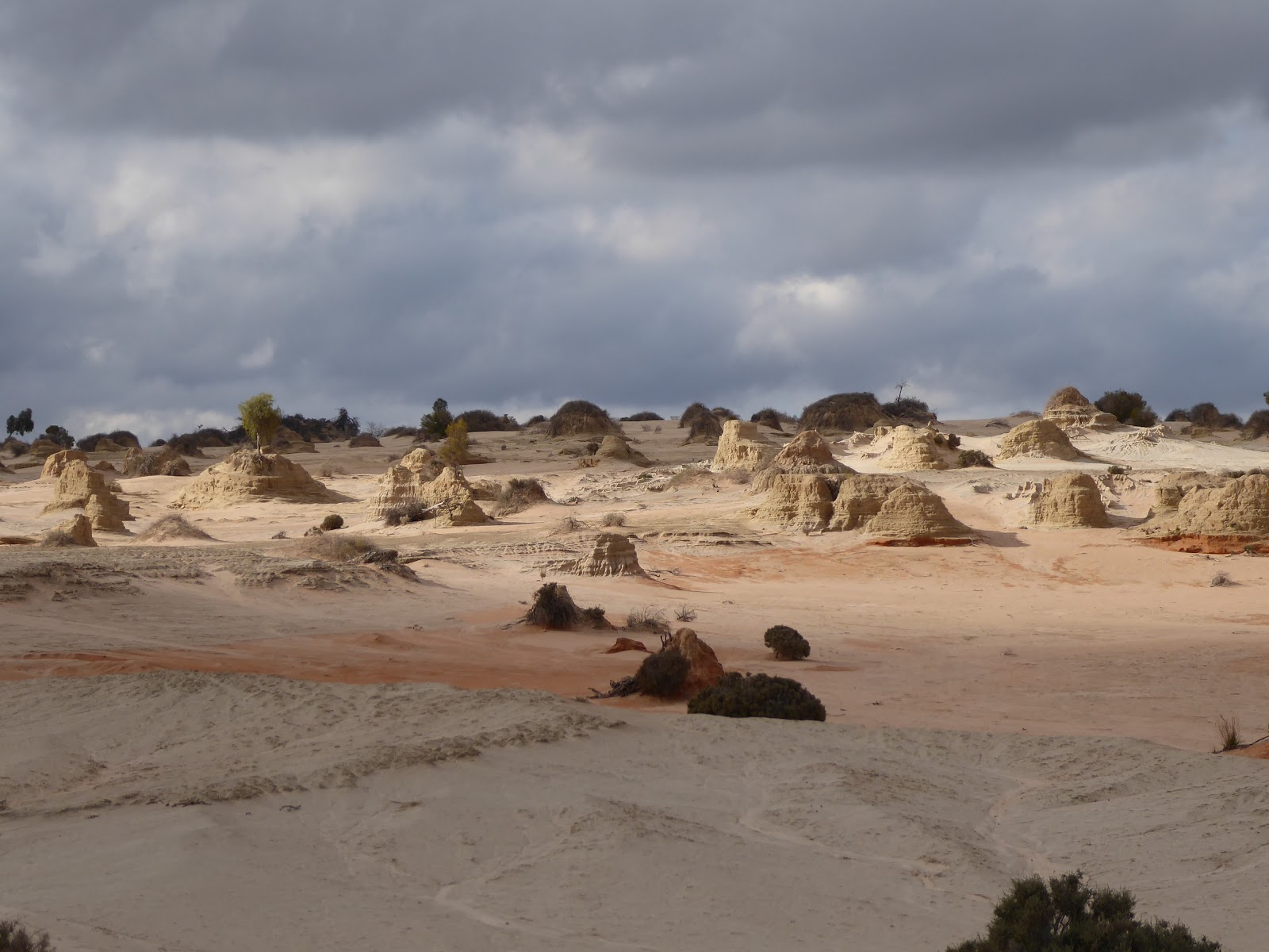
 and there are now boardwalks to walk on to see the Walls of China (hills with eroded mounds) at the Walls Lookout. The Walls of China are basically an area on the moon-shaped (Lunette) eastern side of the lake 38km long where the sand was blown to , and then eroded into strange mounds.  You can see the varying colours from the various times of deposition.


The red colour comes from 100,00- 120,000 years ago, the grey is from 50,000 to 25,000 years ago and the paler brown is from 25,000 to 15,000 years ago.  

Further along the drive you come to another boardwalk (At Red Top Lookout) where you can get up close to the erosion and see how it looks.


The formations really are quite extraordinary!! You do get a feeling that history has happened here.

Further along the drive we stopped at Rosewood Rest (among a stand of Rosewood trees on a red sand hill) to have a very late lunch


 The Mallee Stop, a little further on, gave us the opportunity to learn a bit about telling the difference between species of Mallee, and educated us on the lichen on the ground, and porcupine grass (spinifex) which is currently in flower on the 500m walk and through this area of the park. 
mallee

This particular mallee has bright orange/ red buds - very noticeable right at the moment. 
We came past the ruins of the old shepherd's hut (originally dragged here on a sled from the main station) - now just a pile of wood and metal among rabbit warrens  and wandering emus on the exposed plains. 


and later arrived at a dam (Round Tank) where a goat trap used to be set up and used.  The remnants of the goat trap remain and were interesting. The ramp (below) was for the feral goats to go up.  They would then jump over the end to get to the water (dry dam at the moment) .  The fence was high enough to keep them by the dam until they were rounded up into the yards and up the ramp (second photo below) to be taken away for culling, and thus removed from the park.  The whole thing is currently in disrepair, with a higher fence further out around the dam.


Further around the loop we came to the old Zanci Station homestead site - still with old chimney, underground covered tank and old dugout where the owners used to take refuge when it was really hot.
 Zanci station was annexed into the Park in 1984. You can still see the old border fence as you cross it. 


The old underground dugout. Refuge from searing heat. 

A final view over the dry lake as we left the park gave us the opportunity to take in the enormity of this amazing scene.


On our rather rushed trip back to Mildura we were treated to a great sunset over the vast Aussie plains.